The Political Landscape
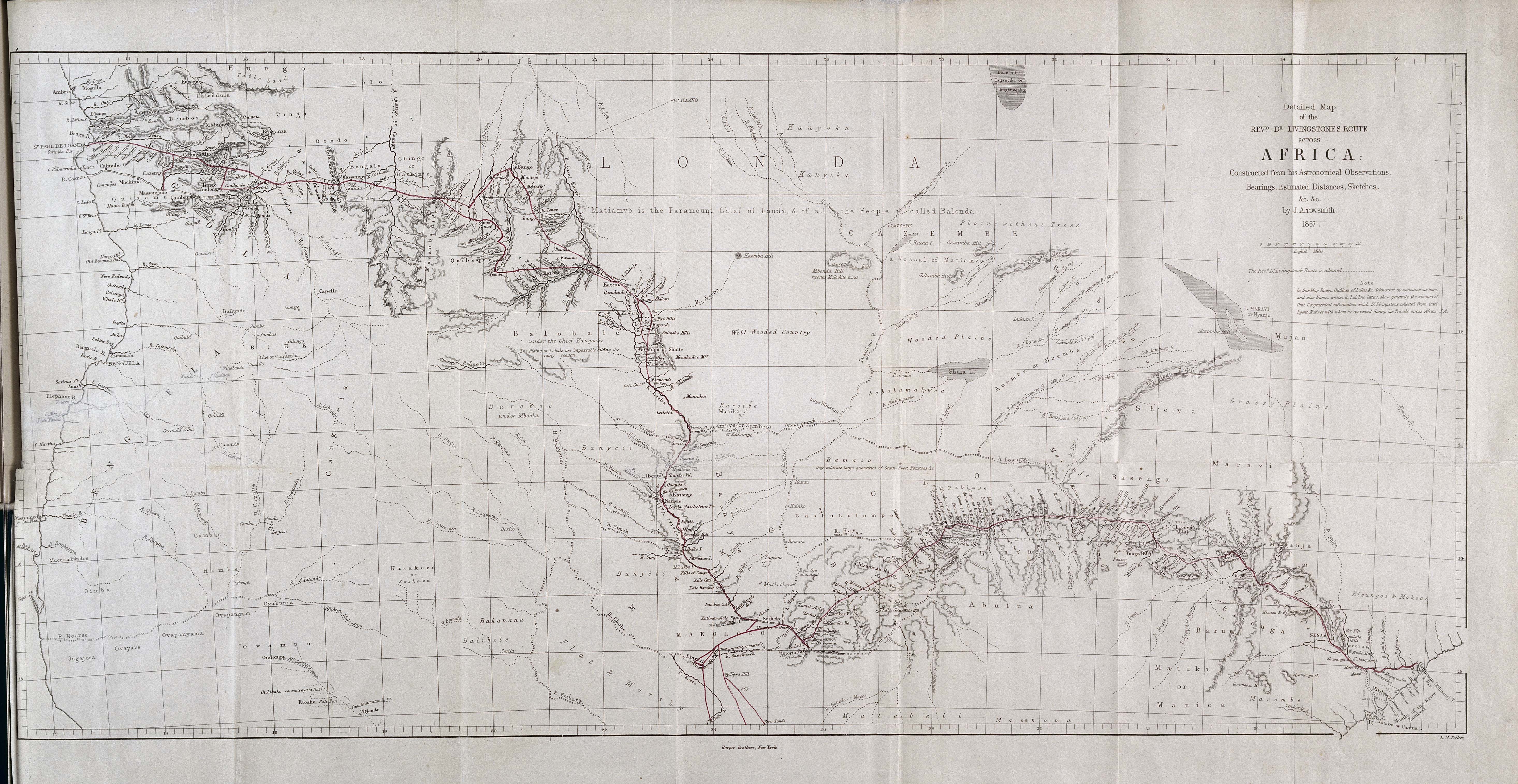
Mapping references to Livingstone lantern shows reveals that the local context of these events did more than shape the tone of the dialogue. Since Livingstone brought a lantern with him on all three of his expeditions, one would expect to see a geographic distribution of references to the lantern show that follows his path through Africa.
Proportionally, Livingstone spent far more time along the western portion of the Zambezi and in the area between Lakes Malawi and Tanganyika than he did in east of Mosi-oa-Tunya. Instead, the points cluster within a 200 mile radius of Kabompo along the upper Zambezi in what’s now Zambia.
The map reveals that Livingstone was most actively remediating his lantern shows during his first expedition. Livingstone was traveling through this area on his way from Linyanti to Luanda between November 1853 and February 1854. He would revisit many of these towns on his way back to Linyanti in 1855. While on his way to the coast, Livingstone would cross paths with ethnically and linguistically diverse ethnic groups, many of whom would not be considered indigenous to the parts of Africa in which he encountered them. These diverse groups formed Livingstone’s lantern show audiences. I will argue that these audiences co-opted the lantern show as a means to demonstrate their political authority and to negotiate a more favorable position within pan-African trade networks.
The ripple effect of the Mfecane
The political landscape through which Livingstone traveled had been shaped by warfare, massacres, and mass migration, a period known in isiZulu as the Mfecane, or “the crushing.”[2] Rumblings of war began in the late eighteenth-century among three northern Nguni communities who lived in what’s now northeastern South Africa. Historians disagree as to the root causes of the conflict, citing the introduction of maize in Nguniland, subsequent droughts and famines, and increasing competition for grazing land and ivory.[3] The Ndwandwe invasion of Ngwane territory in 1817 functions as the proverbial match that lit the powder keg, causing a chain reaction of events that led to the death of King Dingiswayo and the rise of Shaka Zulu in his place. Shaka reinvented amaZulu military tactics, introducing a new form of thrusting spear and refining battle formations. By the 1820s, he had consolidated his power along the western coast of South Africa through diplomacy and conquest, including the defeat of the Ndwandwe at battles on Gqokli Hill and at the confluence of the Mhlatuze and Mvuzane.[4]Zulu expansion would displace a number of Nguni and seSotho communities, who, in turn, would conquer and resettle the areas further north and inland. The domino effect created by this migration would reach as far north as Mosi-oa-Tunya. The two groups that had the most profound effect on the area around Linyanti (currently, northern Botswana) were the Ndebele and the Kololo. In 1822, one of Shaka’s most powerful vassals, Mzilikazi , broke with amaZulu and lead his people the Khumalo further inland. Along the way, Mzilikazi forged an expansive empire of his own, raiding Tswana villages as he went. The Khumalo eventually settled the region around Bulawayo (now part of Zimbabwe), and there became known as the Ndebele. Mzilikazi established a friendship with Robert Moffat, who was sent by the London Missionary Society to South Africa in 1817 and who would later become Livingstone’s father-in-law. Mzilikazi and Moffat met in 1830 and 1835. Their relationship was so strong that the King helped Moffat locate and procure the wood that he needed to build the mission station in Kuruman, which would in turn function as the gateway for missionary activity to the interior.
The Mfecane also pushed the Fokeng, a seSotho-speaking people, out of South Africa. Under the leadership of Sebitwane, the Kololo (as they would later be known) reached the Tonga plateau in Zambia and conquered the Lozi kingdom in 1840, making vassals of the Lozi, Toka, and Mbunda. In 1849, Sebitwane welcomed Livingstone into his court, and in 1853 Sebituane’s successor, Sekeletu, made Livingstone an “nduna,” a representative of the King. The Kololo were especially eager to secure Livingstone’s favor as a means to safeguard against Ndebele raids. Because Livingstone had married Robert Moffat’s daughter, the Kololo and the Lunda reasoned that Mzilikazi would not attack Moffat’s family members. If David and Mary Livingstone stayed in the area, the Kololo-Ndebele border would be relatively safe and stable.
For the Kololo, Livingstone also represented an opportunity to renegotiate their place within pan-African trade networks. Before Livingstone arrived, the Kololo had contact with Portuguese traders at Benguella on the Atlantic Coast through Ovimbundu middlemen along the Kwando River and over the Bihe plateau. Though initially resistant to the slave trade, the Kololo began selling slaves in order to procure guns for defense against the Ndebele to the east, but by the 1850s, there was a greater demand for ivory. The extent of this trade route is represented in Livingstone’s manuscript and published maps, for they contain details about the terrain that would have been familiar to traders interacting with the Ovimbundu. Livingstone purposefully avoided this route for he did not want to “travel in a path once trod by slave-traders,” opting instead for a route that followed the Zambezi more closely.[5] For this journey, Sekeletu provided the man-power and supplies that Livingstone needed for his trans-African expedition. He sent twenty-seven men with Livingstone, two of whom were Kololo— the rest from conquered communities.[6] To create this new trade route, the Kololo would need to strengthen diplomatic ties with the Lunda who lived to the north of the Lozi flood plain. To make matters more challenging, Kololo cattle raids had created diplomatic tensions, and the Lunda court structure was similar to the one that the Kololo had overthrown when they conquered the Lozi.
However, expanding trade would ultimately destabilize this political landscape. Eric Flint argues that shifting the terminus of trade with the coast from Linyanti to the Lozi floodplain ultimately undermined the Kololo’s political authority. By bypassing Kololo and Mambari traders, the Lozi would have more direct access to goods. I would add that this option would have been particularly attractive because the Lozi had more linguistic and cultural affinities with the Lunda to the north than they did with the Kololo who had migrated from the south. Flint also suggests that the trade network built with Livingstone’s assistance created a divide between older Kololo leaders, whose authority was built upon military might and cattle raids, and younger ones, who would serve the king through successful trade negotiations. Mounting tensions between the Lozi and the Kololo would come to a point in 1864 when Sipopa Lutangu overthrew the Kololo. Although the Kololo kingdom would last only 24 years, they left a permanent linguistic imprint on the area, one that would have significant ramifications for missionary activity.The language originally spoken by the Lozi, which Livingstone characterized as “Serotse,” was closer to the dialects spoken by the Lunda and Luba to the north. The seSotho spoken by the Kololo reflected their southern origins and was similar to the seTswana that Livingstone had learned in Kolobeng and Kuruman. As Livingstone moved further north, he would rely increasingly on Kololo and Lozi translators, particularly when giving public addresses with the aid of his lantern. In the years following the Lozi restoration, the languages spoken by the Kololo and Lozi began to merge, making it easier for European and African missionaries from the south to communicate with communities in the interior.[7]
As I will demonstrate, this political, cultural, and linguistic landscape had a profound effect on the tone of Livingstone's lantern shows. In the sections to follow, I will explore how responses to the lantern ranged from raucous storytelling and socializing to calculated performances of power. These shifts correspond to changes in the physical terrain which in turn shaped the cultural and ethnic composition of the communities who inhabited these areas. I argue that African responses to the lantern show resonate as demonstrations of agency. I will also discuss how Livingstone mediated this environment through field-authored documents and published narratives. I will show how his accounts, particularly of his lantern show, downplay African agency in order to foreground his own labors as a missionary and proponent for British trade networks.
[1] “Interstitial Cartographer: David Livingstone and the Invention of South Central Africa.” Victorian Literature and Culture, vol. 37, no. 1, 2009, 255-71.
[2] In seSotho, this period is characterized as the “Difequane” or “Lifequane.” Though these terms are similar in meaning to Mfecane, they emphasize the ways that Shaka Zulu’s expansion contributed to forced migration.
[3] Elizabeth Isiche, A History of African Societies to 1870, Cambridge University Press, 1997, p. 400. See also Robert W. July, Precolonial Africa: An Economic and Social History, Charles Scribner’s Sons, 1975.
[4] Donald R. Morris, The Washing of the Spears, Jonathan Cape, 1965.
[5] Eric Flint, “Trade and Politics in Barotseland During the Kololo Period,” Journal for African History, vol. 10, no. 1, 1970, p. 73.
[6] Tim Jeal, Livingstone: Revised and Expanded Edition, Yale University Press, 2013, p. 131.
[7] siLozi, the language spoken by the Lozi now, is a mixture of seLuyana and Kololo seTswana.