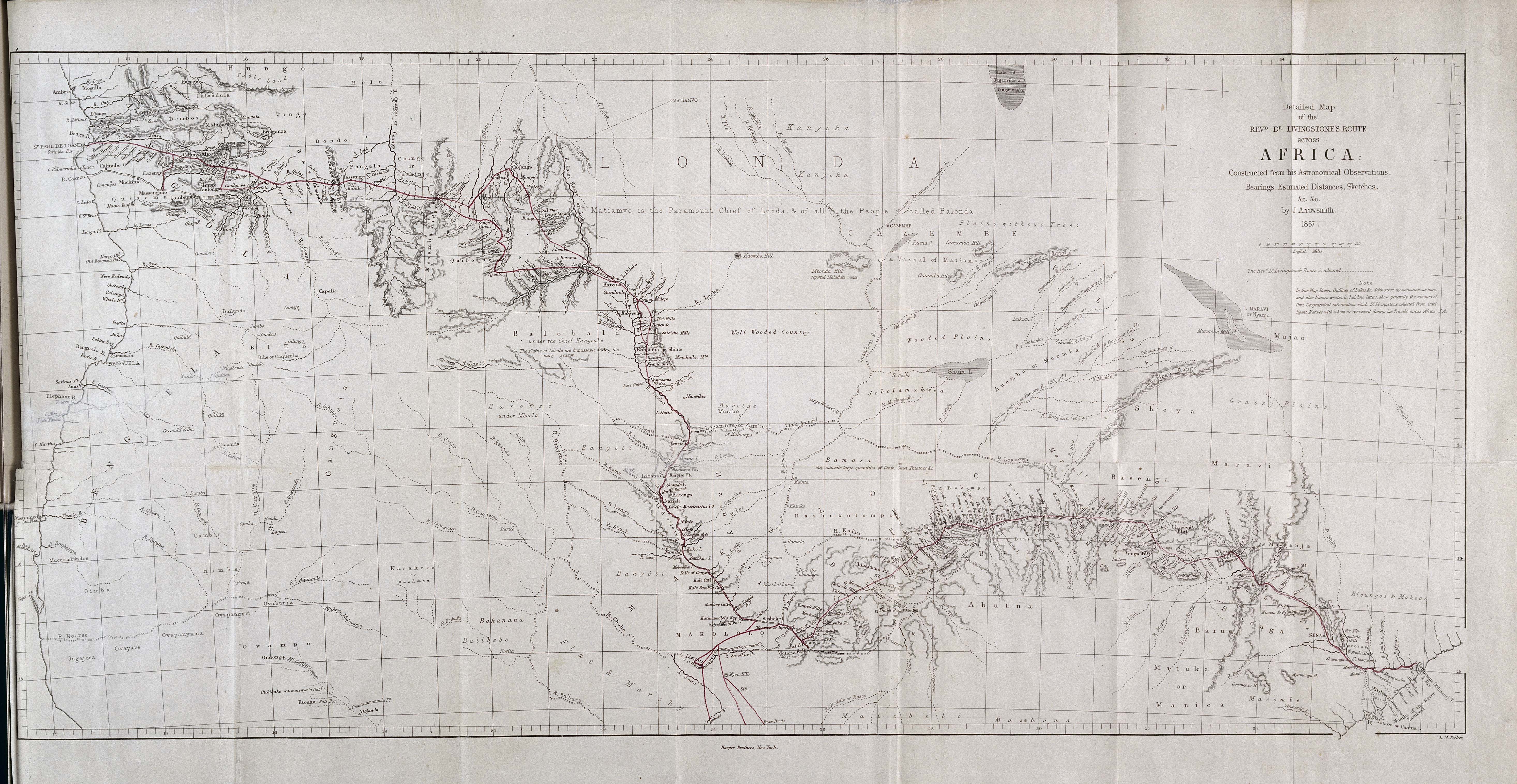
Detailed map of the Revd. Dr. Livingstone's Route Across Africa: Constructed from his Astronomical Observations, Bearings, Estimated Distances, Sketches.
1 2019-07-11T17:09:27+00:00 Mary Borgo Ton users/2BlueFish! 6a775e7f93db4e4e6947fe3f00ce9724b7a7edb3 1 1 By J. Arrowsmith for publication as a supplementary map in Missionary Travels (John Murray: 1857) plain 2019-07-11T17:09:27+00:00 Mary Borgo Ton users/2BlueFish! 6a775e7f93db4e4e6947fe3f00ce9724b7a7edb3This page is referenced by:
-
1
2018-08-28T23:41:13+00:00
“O! that the Holy Spirit would enlighten them": Reconstructing Livingstone’s African Audiences
17
image_header
147
2019-08-15T23:55:26+00:00
Livingstone’s 4,000 mile journey from Linyanti in what’s now northern Botswana to the Atlantic coast and back established his reputation as one of the most eminent Victorian missionaries and explorers. The published account of this expedition, Missionary Travels and Researches in South Africa, became an instant best-seller and has remained a perennial fixture in scholarly discussions about Victorian missionary activity. The expedition represented a pivotal moment in his career. Born into a Glaswegian mill family, Livingstone studied medicine at Anderson’s College with hopes of becoming a medical missionary. He joined the London Missionary Society in 1838 and departed for South Africa in December 1840, months after the memorial services for John Williams. Livingstone would spend eleven years in various stations north of the Orange River learning to speak seTswana and gathering information from Africans about rivers to the north. Upon reaching the Zambezi in 1851, Livingstone began planning an expedition to Luanda on the Atlantic Coast with the support of Sekeletu, the chief of the Kololo.[1]
For his journey to the coast, Livingstone packed four tin boxes. Three of these boxes contained items that one might expect an explorer and missionary to carry: food, survey equipment, trade goods, spare clothing, a tent, and a Bible. The fourth was devoted entirely to a tin improved phantasmagoria lantern and its accompanying slides. This, he used to project biblical material as he explained the main tenets of Christianity. For someone devoted to carrying “as few ‘impedimenta’ as possible,” the lantern seems out-of-place. In Missionary Travels, Livingstone justifies the lantern’s place in his baggage train by presenting the lantern as a powerful educational tool.[2] His account of his expedition includes a particularly eventful lantern show before a Lunda Ishinde, a local chief, named Kabompo.[3]
Livingstone portrays the lantern show as a fundamentally visual and sonic medium. His description of the accompanying narration suggests that projected images helped overcome linguistic barriers, particularly among Africans who did not speak a variant of seTswana. The lantern supported Livingstone’s evangelistic work by attracting large crowds, some of which may have numbered in the hundreds. There were at least 1,000 at Livingstone’s initial reception in Kabompo, and the presence of the Ishinde’s court several days later at the lantern show suggests that there was an equally large audience.[5][Shinte] had his principal men and the same crowd of court beauties near him as at the reception. The first picture exhibited was Abraham about to slaughter his son Isaac; it was shown as large as life, and the uplifted knife was in the act of striking the lad; the Balonda men remarked that the picture was much more like a god than the things of wood or clay they worshiped. I explained that this man was the first of a race to whom God had given the Bible we now held, and that among his children our Savior appeared. The ladies listened with silent awe; but, when I moved the slide, the uplifted dagger moving toward them, they thought it was to be sheathed in their bodies instead of Isaac’s. “Mother! Mother!” all shouted at once, and off they rushed helter-skelter, tumbling pell-mell over each other, and over the little idol-huts and tobacco-bushes: we could not get one of them back again. Shinte, however, sat bravely through the whole, and afterward examined the instrument with interest. An explanation was always added after each time of showing its powers, so that no one should imagine there was aught supernatural in it; and had Mr. Murray, who kindly brought it from England, seen its popularity among both Makololo and Balonda, he would have been gratified with the direction his generosity then took. It was the only mode of instruction I was ever pressed to repeat. The people came long distances for the express purpose of seeing the objects and hearing the explanations.[4]
Among all the magic lantern shows given by missionaries, the show in Kabompo has received the most scholarly attention thanks in part to Livingstone’s centrality in discussions of the nineteenth-century missionary movement, African history, and colonization. As Justin Livingstone has observed, biographies of Livingstone have tended to follow the interpretive mode du jour; these range from late-Victorian narratives that lionize Livingstone (Thomas Hughes, 1901) to scathing pathographies (Judith Listowel, 1974; Tim Jeal, 1973, revised and expanded 2013) to feminist studies of Mary Livingstone, his wife, and his family (Jamet Wagner Parsons, 1997; Julie Davidson, 2012).[6] Similarly, interpretations of Livingstone’s lantern show have challenged the overly celebratory view of Livingstone’s missionary activity. Tim Jeal characterizes Livingstone’s efforts to dispel the aura of the supernatural as ultimately unsuccessful; Jeal frames this interpretation by portraying the Lunda as gullible and prone to believe the stories told to them by other African groups that the white men came from the sea.[7] James R. Ryan focuses instead on the lantern’s status as a mechanical novelty. Though outside the scope of his study, Ryan briefly mentions Livingstone’s packing list for the Zambezi expedition to say that the lantern “also served to demonstrate the superiority of European technology.” For Ryan, Livingstone’s lantern shows anticipate the ways that the lantern lectures produced by the Colonial Office Visual Instruction Committee distributed and reinforced British supremacy.[8] T. Jack Thompson also situates Livingstone within the context of other lantern shows, but Thompson focuses on later missionaries who made lantern lectures with photographs that they had taken while in Africa, including John and Alice Harris’ “Congo Atrocities” which called for sanctions against King Leopold.[9] In each of these cases, the lantern is interpreted as an agent of imperialism as both an educational tool and as a technological novelty.
Despite the fact that Livingstone’s lantern show in Kabompo has served as a touchstone for conversations about missionaries as agents of empire, studies of this moment rely almost exclusively on this passage from Missionary Travels, overlooking references to other lantern shows in this text and in Livingstone’s letters, journals, diaries, and field notes. In this case study, I turn to Livingstone’s field-authored documents, his other published narratives, and extant examples of projectors and slides to reconstruct the content of Livingstone’s lantern shows through the details given in the Missionary Travels account. I then place this show within the context of his travels more broadly. From Livingstone’s perspective, the lantern served a double purpose in that it presented the main tenets of Christianity while also functioning as a potent visual representation of the benefits of increased trade with England. By comparing the content of his lantern shows to commercially available scriptural slides, I expand the argument made by other scholars by showing how Livingstone’s narration of the slide of Abraham aligns with covenant theology. However, the geographic distribution and temporal scope of references to the lantern in Livingstone’s writings indicate that Africans co-opted the lantern show to negotiate a more advantageous place within pan-African trade networks. Rather than seeing Livingstone’s audiences in black and white terms, I foreground the ways in which the lantern show brought together Africans from diasporate ethnic groups, many of whom had been displaced by warfare and the slave trade. Though his audiences would have been characterized as “native” by European standards, many of the Africans who Livingstone met would not be considered indigenous to the regions in which Livingstone encountered them. I argue that chiefs’ responses to Livingstone’s lantern shows register as calculated performances of power. Demonstrations of bravery, wealth, and authority were not only designed to impress Livingstone but were also intended to command the respect of the Africans traveling with him. In this manner, the lantern show became a vehicle for African agency within the pan-African ivory trade.
This emphasis on increasing commerce with the African interior as a means to combat the slave trade would become the primary focus of Livingstone’s subsequent expeditions. Although Livingstone never stopped being a missionary, he broke formal ties with the LMS in 1855 in order to devote his energies to exploring the Zambezi. With the support of the Royal Geographic Society, Livingstone began a second expedition in 1858, this time to investigate whether the Zambezi could function as a highway to the interior. These hopes were dashed when they encountered the Cabora Rapids. To make matters worse, tensions among members of the expedition were high, and many were openly critical of Livingstone’s leadership. Livingstone returned to England in 1864 but sailed for Africa two years later to search for the source of the Nile until his death in 1873. It was during this final journey when he lost contact with his family and friends, sparking Henry Morton Stanley’s search for Livingstone and the now immortal encounter. Inventories and personal letters indicate that Livingstone brought a lantern with him on the Zambezi expedition and his travels in the Lake Tanganyika region, but he devoted the most narrative space and energy in describing the lantern shows that he gave on his way to the coast during his first expedition.[1] For a brief biography, see “Livingstone’s Life and Expeditions” by Justin D. Livingstone (no relation).[2] Missionary Travels, John Murray, 1857, p. 230.[3] Livingstone refers to the Ishinde by his official title, “Shinte.” Livingstone uses the Ishinde’s name, Kabompo, to refer the town where the Ishinde lived. To avoid confusion, I use the term “Kabompo” to refer to the village and “Ishinde” to refer to the person.[4] Missionary Travels, pp. 298-299.[5] Livingstone: Revised and Expanded Edition, Yale University Press, 2013, p. 131.[6] “Revisionism: sins, psyche, sex,” Livingstone’s ‘Lives’: a metabiography of a Victorian icon (Manchester University Press: 2014), pp. 272-291. This overview appears in a condensed form in “Livingstone’s Posthumous Reputation.”[7] Livingstone: Revised and Expanded Edition, pp. 133-4.[8] Picturing Empire, University of Chicago Press, 1997, p. 31. For his discussion of the COVIC, including a fascinating analysis of the COVIC’s photographer, Hugh Fisher, see pp. 183-213.[9] Thompson also includes an extended discussion of the collection of lantern slides at the Livingstonia mission station in Malawi that were used by missionaries at the turn of the twentieth-century onwards. “Missionaries and the Magic Lantern,” Light on Darkness? Missionary Photography of Africa in the Nineteenth and Early Twentieth Centuries, Cambridge University Press, 2012, pp. 207-238, and “David Livingstone’s Magic Lantern, United Kingdom,” Trophies, Relics, or Curios? Missionary Heritage from Africa and the Pacific, Karen Jacobs, Chantal Knowles, and Chris Wingfield, editors, Sidestone Press, 2015, pp. 94-97. -
1
2019-06-25T17:46:51+00:00
Mapping Materialities with Digital Tools
2
plain
2019-07-22T15:04:21+00:00
Digital remediation not only helped me locate relevant archival material, but this process also helped me identify and analyze underlying literary tropes in the texts, particularly in the writings of David Livingstone. As an outgrowth of my work with Livingstone Online, my research questions about his use of the lantern shifted from the show’s content to his African context. I was curious to see how local communities shaped the overall tone of his shows. Visualizing these patterns required me to translate information about his lantern shows into a form that would be conducive to digital spatial analysis. However, remediating Victorian maps into digital ones calls attention to the fact that these documents are subjective and embodied experiences of social landscapes. Livingstone’s maps and their digital counterparts offer a degree of geographical specificity than what was technologically impossible in the nineteenth-century. Overlaying prose onto this landscape with Esri Storymaps and Scalar offers a means to the reinscribe these shows within their social landscape, even though I was unable to represent these communities visually on the map in this iteration of the project.
I presented an early version of this map at the North American Victorian Studies Association conference in Phoenix in 2016. Although I’ve updated the details below so that they describe this iteration of the project, I’ve maintained the narrative style of the presentation to preserve its original form as an orally-delivered paper.
Given Livingstone’s reputation as the consummate Victorian explorer, I thought that this intellectual ground had been covered before. It was natural to assume that someone had already worked out Livingstone’s trajectory and had assigned geographic coordinates to the pivotal moments of his expedition, especially this encounter with Ishinde. But all of the maps that I found offered a macroscopic view. This meant that my attempt to locate Kabompo would be the first to locate this place within a 50 mile radius. Giddy with joy at the discovery of this lacuna, I thought that locating Ishinde on a modern map would be relatively easy. After all, Livingstone carried survey equipment with throughout his travels.
The archivists at the Royal Geographical Society informed me that Livingstone was actually a pretty terrible geographer. He had a bad habit of connecting rivers without confirming that they were part of the same body of water. By “connecting the dots,” he created rivers that apparently flowed in rectangles. What’s more, he had difficulty calculating longitude because he relied on the position of the moon rather than using a chronometer. His frequent bouts of fever made it difficult to produce an accurate reading of his sextant. So while his latitude measurements were fairly accurate, it’s often difficult to tell how far east or west he was on that line. So the coordinates that he offered in Missionary Travels were not reliable. To make matters even more challenging, digital mapping tools require a degree of specificity that Livingstone considered impossible to measure while in Central Africa.
My first attempt to locate Ishinde used print technology as my base. Theresa Quill, IU’s mapping librarian, suggested taking a scan of the Missionary Travels map and molding it to a modern map of southern Africa using the map-warping tool built by the New York Public Library. The process involves pinning known parts of a historical map to a modern one. The software then skews the image of the historical map in order to accommodate the pins. Map warpers work especially well for urban areas and for European spaces thanks to extensive efforts in the nineteenth-century to create accurate surveys of these spaces. Since Livingstone took his measurements once, they lacked the accuracy of maps of European terrain. The inaccuracies in Livingstone’s map were compounded by the fact that publically available maps of this region contain little information about key landmarks. Without the names of rivers, hills, or small towns, I was unable to identify few landmarks close to the Angola/Zambia border. This ultimately reduced the map warper’s accuracy. What’s more, the software treats a three-dimensional surface as a two-dimensional plane, so the warped image did not take the region’s topography into account. Villages ended up in the middle of lakes, rivers in the middle of trees—utter chaos.
The solution to this dilemma required a combination of Victorian technology, nineteenth-century print material, and modern visual navigation tools. The archivists at the Royal Geographical Society directed me Tactical Navigation Charts or TNCs—which are designed to help pilots navigate by sight. These maps show flood plains and vegetation, making them particularly useful for reading the African terrain. Yet, the typeface on the Missionary Travels map and the TNCs were almost impossible to read due to their miniscule scale. The best magnifier for these sorts of documents is actually the condenser from an improved phantasmagoria lantern which was originally designed to magnify the light from an oil lamp. In other words, I resorted to reading maps through the lens of the lantern in the most literal sense.
Thus armed with the condenser from a Victorian projector, I was able to identify topographical features like the Soloishe Hills, helping me to see the similarities between these two documents. The orientation of the hills is puzzling from a bird’s eye view, but when treated as visualization of an embodied experience of a landscape, the Missionary Travels map suggests that Livingstone traveled over parts of these hills on his way to Shinte’s, resulting in the horse-shoe shape that you see here. What also became more visible were Livingstone’s errors. By spotting the differences between these two maps, I was able to rule out the places that he most likely did not see. Around Lake Dilolo, for example, you’ll notice that Livingstone draws connections between rivers that should not be there. The TNC’s legion then enabled me to assign geographic coordinates—12 degrees, 32 minutes, 30 seconds South: 22 degrees, 57 minutes East.
While it is impossible to know exactly which route Livingstone took, comparing topographical features generates coordinates within a ten-mile margin of error, offering an unprecedented degree of geographical specificity. But my delight stems not from this maps precision but how it reshaped my understanding of Livingstone’s writing practices and his African context. To be sure, mapping magic lantern shows specifically and travel narratives more broadly puts me in a similar position to the Victorian arm chair geographers who spent their days correlating maps without ever having seen these spaces. Representing Livingstone’s expedition through a new digital visualization is not an effort to perpetuate the tendency to heroize a Victorian explorer. Rather, it is an attempt to restore African perspectives to visualizations of this region’s history.
This process drew my attention to the incredibly complex political landscape through which Livingstone traveled and the ways in which the physical terrain shaped emergent trade networks. The geographic and temporal distribution of Livingstone’s lantern shows suggests that this physical and social millieu not only affected the tone of his lantern shows, but also contributed to when and where Livingstone wrote about his context. In the Livingstone chapter, you’ll see the maps overlaid with prose describing how the Kololo expedition navigated the increasingly tricky political terrain as they traveled toward the coast. In this mapping endeavor, my mapping ambitions exceeded my technical expertise. Ideally, the map with the modern country labels would be replaced by a satellite image that labeled natural features. Due to an inscrutable setting buried deep in the base map’s nesting layers, I could not find a way to make the labels describing land formations and waterways appear large enough to be read on a pan-African scale. (They appeared rather mysteriously only when the user was zoomed into to a 30 mile radius of a particular point.) Should this project move to another platform, I would strongly consider using an open-source GIS tool like Mapbox to create more sustainable maps, provided that I had sufficient javascript support.